
L’origine degli sciami sismici ai Campi Flegrei. Aggiornamento.
di Mauro Di Vito, Francesca Bianco e Carlo Doglioni
vedi sotto la versione in inglese – below see english translation
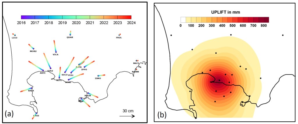
Da millenni la caldera dei Campi Flegrei è sede di intensa attività vulcanica. La vitalità di quest’area irrequieta è manifestata anche dal rilascio concentrato di gas lungo delle sorte di camini che producono le fumarole, e dal bradisismo, cioè il lento sollevamento o abbassamento del suolo, fenomeno quest’ultimo accompagnato anche da attività sismica. Gli episodi più recenti di instabilità che si sono manifestati con sollevamento e sismicità sono stati quelli del 1969-72 e del 1982-84, quando molti abitanti dell’area, soprattutto quelli del centro storico di Pozzuoli, furono costretti ad abbandonare le proprie case. Dal 2005 a oggi è di nuovo in atto un lento sollevamento del suolo che a luglio 2023 ha raggiunto circa 113 centimetri nell’area del Rione Terra.
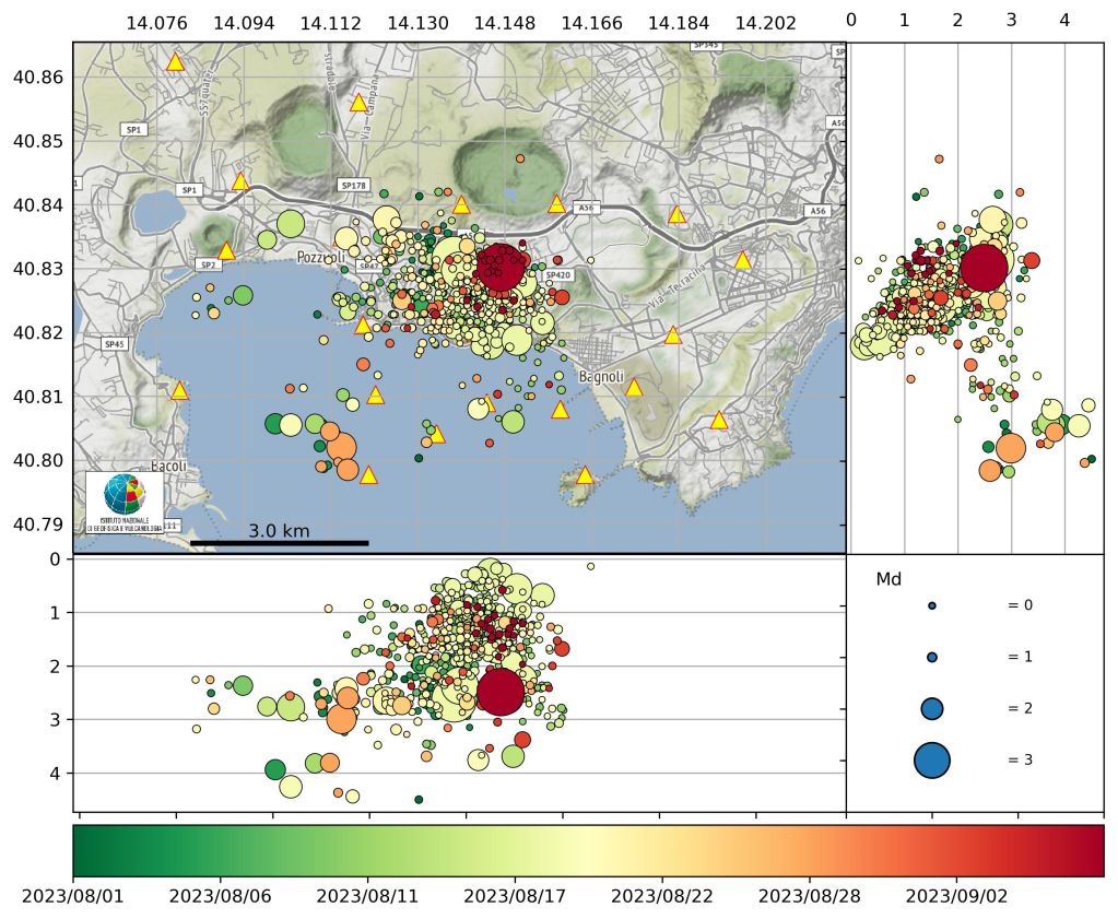
In questi mesi, come riportato nell’ultimo bollettino settimanale di sorveglianza vulcanica (relativo ai dati rilevati dalle reti di monitoraggio dell’INGV Osservatorio Vesuviano al 3 settembre 2023), il valore medio della velocità di sollevamento nell’area di massima deformazione permane a circa 15±3 mm/mese. Nelle ultime settimane si stanno verificando più frequentemente sciami sismici, come quelli avvenuti il 18 agosto e il 7 settembre, con diverse decine di eventi la cui magnitudo massima è 3.8 ± 0.3. L’area sismogenetica principale, già a partire dalla crisi degli anni 80, è compresa tra Pozzuoli, Solfatara, Pisciarelli e Agnano, con eventi che dal 2018 sono presenti anche nel Golfo di Pozzuoli. Le profondità raramente superano i 4 km.
L’ultimo evento rilevante (19:45 del 7 settembre 2023) è avvenuto nell’area della Solfatara ad una profondità di 2.5 km ed ha avuto una Magnitudo durata (Md) pari a 3.8, al momento è il più energetico della fase bradisismica attivatasi alla fine del 2005 attualmente in corso. Tale evento è stato percepito non solo nell’area flegrea, ma in tutta la città di Napoli. Le caratteristiche dell’evento nonché il meccanismo di rottura estensionale sono analoghi a quanto osservato per la maggior parte degli eventi avvenuti nell’area flegrea, in particolare di quelli più energetici.
La deformazione del suolo
L’area che si solleva è centrata sul Rione Terra (Pozzuoli, parte storica) o poco più a sud, e presenta una deformazione radiale, in rapida attenuazione verso la periferia della caldera, con una forma “a campana”. I valori di deformazione locale sono misurati attraverso una fitta rete GNSS e tiltmetrica, integrata con osservazioni satellitari. Dal 2005, e in particolare negli ultimi periodi, la forma della deformazione si è mantenuta simile, a testimonianza che il processo, e soprattutto la sorgente, non mostrano modifiche significative.
La causa del sollevamento
Le misure periodiche geochimiche e quelle in continuo da stazioni fisse sia su fumarole che in pozzo continuano a mostrare che il processo di aumento di pressione del sistema geotermico sub-superficiale è ancora in corso e determina una forte risalita di fluidi maggiormente concentrati nell’area di Solfatara-Pisciarelli. Si ricorda che le misure sono effettuate anche nella parte sottomarina della caldera, nel Golfo di Pozzuoli, dove sono presenti punti di fuoriuscita di gas caldi, come il caso delle “Fumose” a sud di Monte Nuovo, l’apparato conico vulcanico formatosi in pochi giorni a fine settembre-primi di ottobre del 1538.
Gli ultimi sciami sismici, incluso quello del 7 settembre 2023, dimostrano come il fenomeno non mostri cambiamenti sostanziali, seppure avvenga con pulsazioni che si ripetono nel tempo. La causa del sollevamento del suolo e quindi della sismicità può essere dovuta a una forte risalita di gas e una maggiore pressurizzazione del sistema idrotermale profondo. Un’altra possibilità è che si stiano iniettando nel sottosuolo delle lingue di magma alimentate dal sistema magmatico profondo, strutture cosiddette a sill, a circa 3-4 km di profondità. L’origine del sollevamento è dunque legata alla spinta verso l’alto generata dalla messa in posto dei fluidi o fusi magmatici, e il bombamento conseguente genera un inarcamento e allungamento della crosta sovrastante con conseguenti fratture e faglie che generano terremoti e facilitano la risalita dei fluidi idrotermali.
La sismicità è piuttosto concentrata nelle zone di massimo sollevamento e a una bassa profondità (fino a 3-4 km, raramente 5) per l’alta temperatura della crosta terrestre sotto i Campi Flegrei, che fa sì che sotto quelle profondità le rocce si comportino solo in modo visco-plastico; i terremoti avvengono dunque prevalentemente nella stessa area e anche i loro meccanismi sono per lo più gli stessi. Negli ultimi anni la sismicità si è leggermente allargata, evidenza che dimostrerebbe come i fluidi o il magma si stanno lentamente espandendo lungo questa discontinuità orizzontale.
I dati attualmente disponibili indicano perciò che l’origine del sollevamento può essere prodotto da una risalita, probabilmente pulsante, di fluidi di origine magmatica. I fluidi si generano a profondità probabilmente superiori a 6-8 km, all’interno di una vasta e articolata camera magmatica profonda presente sotto i Campi Flegrei, ipotizzata da vari tipi di studi e indagini indirette. Da questo magma provengono le grosse quantità di gas che risalgono per gradienti di densità e quindi di pressione, verso la superficie. In particolare, i gas interagiscono con le rocce superficiali e con il sistema idrotermale superficiale, presente nei primi 2-3 km di profondità. La sorgente di spinta, dedotta dalla modellazione della deformazione del suolo, sembra essere posta intorno a 4 km. La quantità di gas rilasciata è ragguardevole: solo nell’area di Solfatara-Pisciarelli determina, in media, la fuoriuscita di oltre 3000 tonnellate di CO2 al giorno, in buona parte derivante dal degassamento magmatico profondo e dall’interazione del magma con rocce carbonatiche.
La sorveglianza vulcanica ed il monitoraggio, effettuati in continuo dalla sezione dell’INGV-Osservatorio Vesuviano attraverso la sua fitta rete strumentale multiparametrica, mira proprio a definire tutti i possibili cambiamenti nel sistema superficiale e profondo per determinare possibili risalite magmatiche verso la superficie che potrebbero produrre un’eruzione vulcanica.

Evoluzione della crisi bradisismica
Attualmente la probabilità di una eruzione vulcanica è relativamente bassa, proprio perché non vi sono evidenze di risalita di magma verso la superficie. Inoltre, il volume crostale sollevato al momento è pari a dimensioni molto inferiori al km3, vincolando le dimensioni dei fluidi nell’area di alimentazione del sollevamento. I dati sismici, geochimici, le deformazioni del suolo, le variazioni termiche superficiali e in pozzo, le variazioni gravimetriche non forniscono, allo stato attuale, indicazioni che il magma stia risalendo verso la superficie. Tuttavia, il vulcano ha la sua inarrestabile naturale evoluzione e, prima o poi, tornerà a eruttare. L’attenzione dell’INGV-OV è massima nella raccolta, studio e interpretazione dei dati e ogni variazione viene e sarà sempre discussa e comunicata tempestivamente agli organi di Protezione Civile nei suoi vari livelli.
Versione in Inglese
The origin of earthquake swarms in Phlegraean Fields
For millennia, the Campi Flegrei caldera has been the site of intense volcanic activity. The vitality of this restless area is also manifested by the concentrated release of gas along rises of chimneys that produce fumaroles, and by bradyseism, that is, the slow raising or lowering of the ground, the latter phenomenon also accompanied by seismic activity. The most recent episodes of instability involving uplift and seismicity were those of 1969-72 and 1982-84, when many inhabitants of the area, especially those in the historic center of Pozzuoli, were forced to abandon their homes. From 2005 to the present, a slow ground uplift is again underway, which in July 2023 reached about 113 centimeters in the Rione Terra area.
In recent months, as reported in the latest weekly volcanic surveillance bulletin (related to data collected by the INGV Osservatorio Vesuviano monitoring networks as of September 3, 2023), the average value of uplift velocity in the area of maximum deformation remains at about 15±3 mm/month. Seismic swarms are occurring more frequently in recent weeks, such as those that occurred on August 18 and September 7, with several dozen events and maximum magnitude 3.8 ± 0.3. The main seismogenic area, already since the crisis of the 1980s, is between Pozzuoli, Solfatara, Pisciarelli, and Agnano, with events also occurring in the Gulf of Pozzuoli since 2018. Depths rarely exceed 4 km.
The last relevant event (7:45 p.m., Sept. 7, 2023) occurred in the Solfatara area at a depth of 2.5 km and had a Magnitude Duration (Md) of 3.8, at the moment it is the most energetic of the bradyseismic phase triggered at the end of 2005 that is currently in progress. This event was felt not only in the Phlegraean area, but throughout the city of Naples. The characteristics of the event as well as the mechanism of extensional rupture are similar to what has been observed for most of the events occurring in the Phlegraean area, especially the most energetic ones.
Ground deformation
The uplifting area is centered on the Rione Terra (Pozzuoli, historical part) or slightly to the south, and shows radial deformation, rapidly attenuating toward the periphery of the caldera, with a “bell” shape. Local deformation values are measured through a dense GNSS and tiltmetric network, supplemented with satellite observations. Since 2005, and particularly in recent periods, the shape of the deformation has remained similar, indicating that the process, and especially the source, shows no significant changes.
The cause of the uplift
Periodic geochemical and continuous measurements from fixed stations both on fumaroles and in wells continue to show that the process of pressure increase of the subsurface geothermal system is still ongoing and results in a strong upwelling of fluids mostly concentrated in the Solfatara-Pisciarelli area. It should be noted that measurements are also carried out in the submarine part of the caldera, in the Gulf of Pozzuoli, where hot gas outflow points are present, such as the case of the “Fumose” south of Monte Nuovo, the volcanic conical apparatus formed in a few days in late September-early October 1538.
The latest seismic swarms, including the one of September 7, 2023, show how the phenomenon does not show substantial changes, although it occurs with pulsations that are repeated over time. The cause of ground uplift and thus seismicity may be due to strong gas uplift and increased pressurization of the deep hydrothermal system. Another possibility is that tongues of magma fed by the deep magmatic system, so-called sill structures, are being injected into the subsurface at a depth of about 3-4 km. The origin of the uplift is thus related to the upward thrust generated by the emplacement of magmatic fluids or melts, and the resulting bombardment generates an arching and elongation of the overlying crust with consequent fractures and faults that generate earthquakes and facilitate the uplift of hydrothermal fluids.
Seismicity is rather concentrated in the areas of maximum uplift and at a shallow depth (up to 3-4 km, rarely 5) due to the high temperature of the Earth’s crust beneath the Phlegraean Fields, which causes the rocks below those depths to behave only visco-plastically; earthquakes therefore occur mostly in the same area and their mechanisms are also mostly the same. In recent years, the seismicity has expanded slightly, evidence that would show how fluids or magma are slowly expanding along this horizontal discontinuity.
The currently available data therefore indicate that the origin of the uplift may be produced by an upwelling, probably pulsating, of fluids of magmatic origin. The fluids are generated at depths probably greater than 6-8 km, within a vast and articulated deep magma chamber present beneath the Phlegraean Fields, hypothesized by various types of studies and indirect investigations. From this magma come the large quantities of gases that rise by density gradients, and therefore pressure gradients, to the surface. In particular, the gases interact with the surface rocks and the surface hydrothermal system, which is present in the first 2-3 km depth. The source of thrust, inferred from ground deformation modeling, appears to be located around 4 km. The amount of gas released is considerable: in the Solfatara-Pisciarelli area alone it determines, on average, the release of more than 3,000 tons of CO2 per day, much of it resulting from deep magmatic outgassing and the interaction of magma with carbonate rocks.
Volcanic surveillance and monitoring, carried out continuously by the INGV-Vesuvius Observatory section through its dense multi-parameter instrumental network, aims precisely at defining all possible changes in the surface and deep system to determine possible magmatic rises to the surface that could produce a volcanic eruption.
One thought on “L’origine degli sciami sismici ai Campi Flegrei. Aggiornamento.”
Comments are closed.